


PRECINCT YGN5 E, Mahoning County, Ohio
About
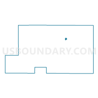
Outline

Summary
| Unique Area Identifier | 649635 |
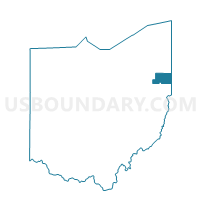
| Name | PRECINCT YGN5 E |
| County | Mahoning County |
| State | Ohio |
| Area (square miles) | 0.24 |
| Land Area (square miles) | 0.24 |
| Water Area (square miles) | 0.00 |
| % of Land Area | 100.00 |
| % of Water Area | 0.00 |
| Latitude of the Internal Point | 41.06739750 |
| Longtitude of the Internal Point | -80.69556690 |
Maps

Graphs
Select a template below for downloading or customizing gragh for PRECINCT YGN5 E, Mahoning County, Ohio


Neighbors
Neighoring Voting District (by Name) Neighboring Voting District on the Map
- PRECINCT YGN5 A, Mahoning County, OH
- PRECINCT YGN5 B, Mahoning County, OH
- PRECINCT YGN5 C, Mahoning County, OH
- PRECINCT YGN5 D, Mahoning County, OH
- PRECINCT YGN5 K, Mahoning County, OH
- PRECINCT YGN5 L, Mahoning County, OH